
Public Meeting
Thursday 25th May 2017 4.30-7.30pm
Hutton Cranswick CP School
Representatives of Williamsfield Developments Ltd., Walker Morris and Sangwin Architects will be available to discuss the proposed development on Williamsfield Road, Hutton Cranswick. Large scale plans of the proposed site will be available for inspection.
Refreshments will be served.
Public Consultation on proposed residential development
The Development
Following the Public Consultation in June 2017, a formal pre-application was made to the East Riding of Yorkshire Council. An outline planning application enquiry has now been made for this site, which was validated on 23rd November 2017. Reference: 17/03880/STOUT
Details can be found on-line through the East Riding of Yorkshire planning portal at https://newplanningaccess.eastriding.gov.uk/newplanningaccess/. The details can also be viewed at any East Riding customer service centre.
An illustrative site plan has been prepared indicating the layout of the dwellings and drives, gardens, density, landscaping improvements, public open space and footpaths. The layout shows a spine road winding north to south through the centre of the development.
The illustrative site plan indicates a mix of house types (detached, semi-detached and some smaller terraced housing). The mixture of types and sizes of dwellings, spread throughout the site, reflects the variety of demand in the village.
The site plan of the scheme is, at this stage, for illustrative purposes only. The plan is nevertheless useful in demonstrating that this development is capable of being delivered on a site of this size, without detriment to the village or neighbouring properties. The layout demonstrates that access can be provided to an acceptable and safe standard; existing and proposed landscaping and planting will create a barrier between the open fields to the south and the residential estate to the west; sufficient areas for public open space can be provided to cater for the proposed dwellings and the wider village and importantly, the number of dwellings proposed is in scale with the size of the village.
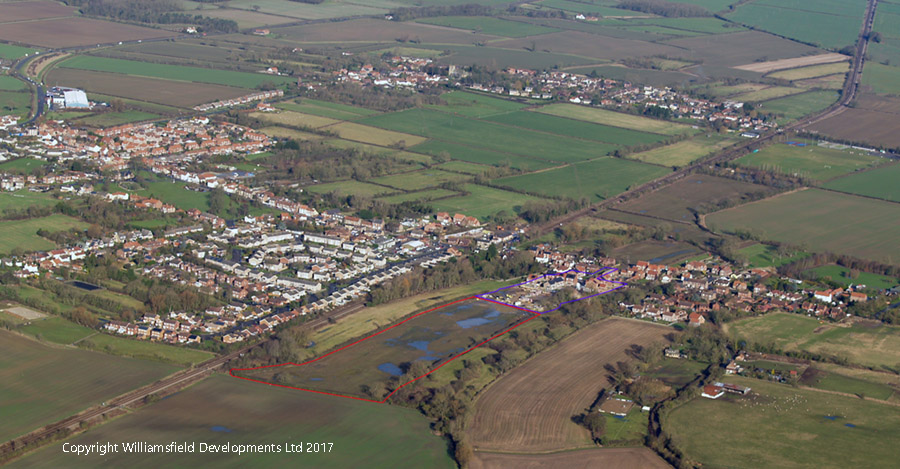
The Site
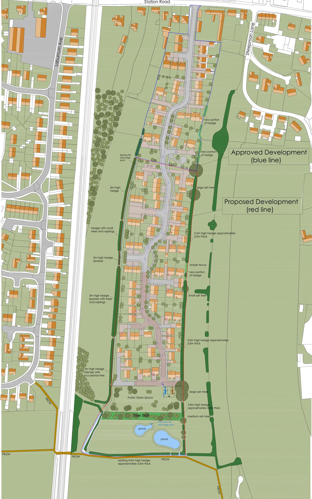
The extent of the proposed outline planning application area is marked in red on the illustrative site plan. The blue line boundary to the north indicates the area already approved for residential development in 2009 and 2011. The approved developments to the north are nearing completion. The Site comprises former agricultural land, with mature hedges forming the field boundaries to the east, south and west. Access to the site will be from Station Road and will utilise the existing spine road running through the residential development to the north.
Affordable Housing
In Hutton Cranswick, the amount of affordable housing to be provided in new developments is set out in the East Riding of Yorkshire Strategy Document (2016). This document advises that in Hutton Cranswick, 20% of new dwellings should be affordable. In an increasingly difficult housing market, Williamsfield Developments Ltd has consistently delivered their affordable housing requirement. The proposed development for 67 dwellings would again seek to deliver the full 20% affordable housing element. There is a significant shortfall in the provision of affordable housing in East Riding. Williamsfield Developments Ltd has already delivered and intends to deliver much needed affordable housing on this site.
Highways
An assessment of the impact of the proposed development on the highways has been commissioned. The findings of this assessment, carried out in February and March 2017, conclude that the site is in a sustainable location with easy access to rail services. There have been no accidents recorded in the vicinity of the site within the last 5 years. The illustrative layout could accommodate 67 dwellings and capable of adoption by the Highway Authority. The turning heads are of sufficient size to accommodate a large refuse vehicle.
A junction capacity assessment of Station Road/Williamsfield Road was undertaken and highlighted that the traffic generated from the proposed scheme could easily be accommodated at this junction, with spare capacity. The level of traffic generated from 67 dwellings is modest and not likely to result in a material impact on the wider highway network.
The proposed development would therefore not give rise to any adverse highway impacts on Williamsfield Road/Station Road or the wider highway network.
Landscaping
The field pattern of the site and immediate landscape display a historic layout, which is typical of Hutton Cranswick. The key landscape features of the site are the vegetated boundaries and field shape. These boundaries and shape will be retained and filled in where there is sparse cover or gaps. The development would be enclosed by the existing natural boundaries.
The additional landscaping to the south of the site, in the form of a 10 metre woodland belt adjacent to Footpath No.14 is intended to create an interface with the local landscape that is well vegetated and built form that is absorbed within this green boundary. Visual effects of the development would therefore be limited from the south. The retention of the hedgerows on the eastern and western boundaries, together with planting of trees where the hedgerow is sparse, would limit views from elsewhere.
The public open space at the southern extent of the Site will include a 10 metre woodland belt, to reinforce existing hedgerows. The area will also include a wildflower meadow with footpaths connecting to the public right of way (Footpath No.14).
Planting would be provided throughout the development to offer landscape integration, screening and amenity landscape for future residents.
The northern area of public open space links to a green space that forms the terminus of the approved development. This space would make provision for informal recreation and consist of ornamental planting, amenity grass, paths and street furniture.
Flooding and Drainage
The site falls within Flood Zone 1, where there is a less than 1 in 1000 (<0.1%) annual probability of tidal or river flooding in any one year. Flood Zone 1 has the lowest probability of flooding.
The foul water drainage strategy will replicate and connect to the previously approved scheme to the north. Yorkshire Water has adopted the drains at the site to the north.
The surface water drainage strategy will consist of underground pipes, discharging to Holmes Dyke in the south west corner of the site.
Have Your Say
Submit your comments by selecting the tab at the top of the page
This consultation page will be available from Monday 22nd May 2017. You will then be able to submit your comments on the proposed residential development.
Public Meeting
Thursday 25th May 2017 4.30-7.30pm
Hutton Cranswick CP School
Representatives of Williamsfield Developments Ltd., Walker Morris and Sangwin Architects will be available to discuss the proposed development on Williamsfield Road, Hutton Cranswick. Large scale plans of the proposed site will be available for inspection.
Refreshments will be served.
You may also email us at consultation@williamsfield.co.uk
or write to us at
Williamsfield Developments Ltd.,
The Courtyard,
Williamsfield Road,
Hutton Cranswick,
Driffield
YO25 9BH
Submit your comments on the form below
You may also email us at consultation@williamsfield.co.uk
or write to us at
Williamsfield Developments Ltd.,
The Courtyard,
Williamsfield Road,
Hutton Cranswick,
Driffield
YO25 9BH
Planning Application
Whilst we will continue to receive consultation submissions,
we will only be able to consider those received by
Friday 9 June 2017 before the planning application is finalised.
Privacy Statement
Information we collect is for our own use, to verify submissions
and allow us to confirm successful receipt. We do not publish
respondent details or provide them to third party organisations
unless legally required to do so.
A summary of consultation responses and our comments will be posted here after the 9th of June 2017
Planning Application
Whilst we will continue to receive consultation submissions, we will only be able to consider those received by Friday 9 June 2017 before the planning application is finalised.
Privacy Statement
Information we collect is for our own use, to verify submissions and allow us to confirm successful receipt. We do not publish respondent details or provide them to third party organisations unless legally required to do so.